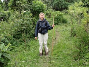
The Rwenzori Mountains are the biggest mountain range in Africa located in Uganda and and Democratic Repblic of Cong ( DRC ) . The snow covered Rwenzori Mountains - also known as the 'mountains of the moon' and protected as Rwenzori Mountains National Park in Ugasnda , which is also a " World Heritage Centre " .
If you been looking for the unique experience in Africa , Uganda is the best to explore!!! The mist-shrouded peaks provide stunning backdrops to these magnificent mountains; including six main mountains with peaks exceeding 4.500 m. of altitude:
- Mt. Stanley,
- Mt. Speke,
- Mt. Baker, Mt.
- Gessi (in the Congolese side), and
- Mt. Emin Pasha.
- Mt. Luigi di Savoia.
(A). Trekking.
When trekking, the Central Circuit is the best way to ascend this big African mountain. The hike starts from Nyakalengija; at the base of the mountain slopes where the park quarters are situated and follows the Mobuku river valley, then sloping around Mount Baker, where is found the final trail to climb Mount Stanley with Margherita Peak.
This trekking passes through five different vegetation zones, from the mountain forest,i.e
- the bamboo zone,
- the alpine zone, with difference in level of altitude from 2.800 m to 3.500 m when you climb the peak. Hikers are advised to respect the gradual acclimatization process to avoid altitude sickness. The trails developed by Uganda Wild Life Authority ( UWA ), have mountain huts, which are basic in style.
Nyakalengija 1600m - Nybitaba Hut 2650m
From the Rwenzori Mountains National Park Head Quarter at Nyakalengija, the hike starts through the plantations and homes of the Bakonjo tribe group, the people of the mountain, gradually reaching garden plots and elephants grass.
You be following the Mobuku River, until crossing the Mahoma River. The trail passes through an open bracken fern slopes and Podorcarpus Forest, up to Nyabitaba Hut, 2.652 m, which is the arrival point for the day. This will take from 5 to 6 hours. From the location, you are facing on the North the Portal Peaks, 4.627 m. and in front Mount Kyniangoma. During the day, you might see monkeys, the Rwenzori Turaco and hearing the sounds of chimpanzees.
Nyabitaba Hut 2650m - John Matte Hut 3380m
Descend the ridge to the Mubuku River then climb through bamboo forest toward John Matte Hut (3380m). The afternoon is tiring boulder hopping ascending along the north side of the Bujuku river through giant heather forest (4.1/2-5.1/2 hours)
John Matte Hut (3380m) - Bujuku Hut 3972m
Trek from John Matte Hut (3380m) to Bujuku Hut (3977m). You will encounter the first of notorious bogs for which the Uganda approach to the peaks is famous. Traverse around Bigo Bog and Lake Bujuku. Look for the 'everlasting flower' known to remain on the plants for 40-years!
Bujuku Hut 3900m- Elena Hut 4541m
From Bujuku Hut you climb through moss draped groundsel vegetation, to Scott Elliot Pass, 4.372 m., between Mt. Baker and Stanley. Here you divert to Elena Hut, 4.540 m. for spending the night before climbing Mt. Stanley.
Elena Hut 4541m - Punta Margherita 5109 m. - Elena Hut 4541m- Kitandara Hut, 4.023 m. - Elena Hut to Margherita peak (5109m) then down Elena Hut 4541m
Early morning traverse of the Elena glacier to the Stanley Plateau where crampons may be required. Cross this in a NW direction and follow the Margherita glacier to the col and to the summit (3 hours). Descend to Elena Hut and after you descend to Upper Kitandara lake and through thick mud to Lower Kitandara lake where is located Kitandara Hut, 4.023 m.
From Kitandara Hut you can proceed for climbing Mount Baker or Mount Luigi di Savoia and the peak Vittorio Sella. Enjoy the view of Mt. Luigi di Savoia.
Kitandara Hut - Guy Yeoman Hut, 3.261 m.
From Lake Kitandara you climb to Freshfield Pass, 4.282 m., a long flat of high alpine mossy glades, before descending the circuit among rocky and boggy areas. The panorama is dominated by the glaciers of Mounts Stanley and Baker and Mount of Savoy. A muddy trail leads to Akendahi, Bujongolo and Kabamba rock shelters, where starts the Kabamba valley down to Guy Yeoman Hut, 3.261 m. This can take up to 6 hours. The hut is surrounded by a beautiful landscape of mountains, vegetations and rivers.
Guy Yeoman Hut - Nyabitaba hut.
Drop very steeply alongside the Mubuku River, past Kichuchu, another rock shelter and join our original route near the confluence of the Bujuku River (3.1/2 hours). This great Rwenzori Adventure will take you between 8 -10 days dpending on your programme. Its enjoyable and such experience will always live your memories.
![644274_573473869329930_569319719_n[1]](https://gorillatrusttourscom.files.wordpress.com/2015/10/644274_573473869329930_569319719_n1.jpg?w=289)
Hikers are normally advised to bring ;
- Sleeping bag,
- rucksack,
- sleeping mat,
- good hiking gumboots,
- water proof trousers,
- rain coat,
- heavy worm jacket,
- hand gloves,
- scarf and cup,
- jumper, t
- torch,
- Light changeable clothing,
- sweaters,
- insect repellants, s
- un cream,
- sun glasses,
- hat,
- binoculars, and cameras etc.
![561599_466560953363246_1135835272_n[1]](https://gorillatrusttourscom.files.wordpress.com/2015/10/561599_466560953363246_1135835272_n1.jpg?w=300)
Rwenzori Mountain Hiking can be challenging, it is highly recommended to be physically fit for such adventure. No sort of illiness , the mountain normally experience heavy rain fall, and some times ,its always drezolling , though not raining!
For more infomation, inquiries about such services, you can contact Gorilla Trust Tours (U) Limited , at sales@gorillatrrusttours.com or log in, www.gorillatrusttours.com.
![417196_472428729443135_1383888691_n[1]](https://gorillatrusttourscom.files.wordpress.com/2015/10/417196_472428729443135_1383888691_n1.jpg?w=300)
Cheers, by
Inno Omunyakigezi
The Blogger.
No comments:
Post a Comment